
Project Name
MAGAL Constellation – Setting the cornerstone of a future ocean and climate change monitoring constellation, based on radar altimeter data combined with gravity and ocean temperature and salinity measurements
Project Code
45916
Intervention Region
Worldwide
Beneficiary Entity
Efacec Energia, Máquinas e Equipamentos Elétricos, S.A.
Duration
July 2020 – June 2023
Project Team
- Promotors
- Efacec Energia Máquinas e Equipamentos Eléctricos S.A
- CEiiA – Centro de Engenharia e Desenvolvimento
- Omnidea Lda
- CIIMAR
- IST – Instituto Superior Técnico
- IT Aveiro – Instituto de Telecomunicações de Aveiro
- UBI – Universidade da Beira Interior
- +Atlantic – Associação para um Laboratório Colaborativo do Atlântico
- Partners
- FGF – Fundação Gaspar Frutuoso
- AIR Centre – Associação para o desenvolvimento do Atlantic International Research centre
- UT Austin – The University of Texas at Austin
Eligible Total Cost
1.894.540,39 €
Financial Support from the European Union
Co-financed by the European Regional Development Fund through COMPETE 2020, LISBOA 2020, PO ACORES 2020 and by FCT under the UT Austin-Portugal interface programme.
Main Objective
Terrestrial hydroclimate conditions are controlled by a suite of mechanisms, including ocean-driven climate variability (such as El Nino–Southern Oscillation, North Atlantic Oscillation, Pacific Decadal Oscillation, Atlantic Multi-decadal Oscillation), longer-term climate conditions caused by greenhouse gases and aerosols, land–atmosphere interactions, land-use and land cover changes, and human water management. Thus, it remains poorly understood what mechanisms are playing what roles in a given region. Nevertheless, the heat stored in the oceans has an important influence on climate change.
Currently the most thorough understanding of the effect of ocean temperature variation and ocean mass change on regional and local climate is limited to locations where Argo floats have been deployed to measure in-situ ocean temperature and salinity. An alternate measurement of the global and regional heat stored in the oceans can be obtained from global measurements of surface topography from satellite altimeters and global measurements of ocean mass from current gravity missions.
Satellite altimetry (SA) is, in fact, considered nowadays a fully operational and mature observing system, especially over open ocean. Several parameters can be derived from satellite radar altimeter measurements, namely global sea surface height (SSH), significant wave height (SWH) and sea surface wind speed. In most studies, e.g. ocean circulation and sea level change, the parameter of interest is the Sea Level Anomaly (SLA), the variable component of SSH. Additional parameters such as ocean dynamic topography can be obtained through independent measurements of the geoid or the mean dynamic topography (MDT), from which surface geostrophic currents can be derived.
The main limitations of current radar altimeters are related with their large footprints (and of their companion microwave radiometer, MWR) and the limited spatial and temporal sampling. For example, TOPEX/Poseidon (1992-2005), the first in a series of satellites solely dedicated to satellite altimetry, flew on a non-Sun-synchronous orbit with a 10-day repeat cycle (127 orbits per cycle) and 315 km inter-track spacing at the equator (much similar to the current Jason missions). Conversely, Envisat (2002-2012) followed a 35-day repeat cycle (501 orbits per cycle) and had a 80 km inter-track spacing at the equator. Finally, Sentinel-3A and Sentinel-3B, launched in 2016 and 2018 respectively, are some of the most recent and most advanced missions, flying in a Sun-synchronous orbit and 27-day repeat cycle, with an equatorial space between adjacent tracks of 104 km.
Remote sensing limitations in spatiotemporal resolution, combined with inadequacies in either data quality, representativeness or coverage of ground-based sensors and land surface modelling, have also an impact in high-quality Earth system data records (such as soil moisture and snow). These are critical for extreme events (droughts & floods) monitoring, water resources management, weather forecasts & climate prediction and other applications and, therefore, would also benefit from an increase in number and frequency of observations from satellites.
General Objectives
MAGAL can advance the understanding of how specific regional and local climates around the globe are affected by ocean temperature variation and ocean mass change. To achieve this long-term goal, the MAGAL project will act as a cornerstone to enable an accelerated development of Portuguese technologies and competencies in the space industry to generate innovation and industrial development and integrate and operate complex systems for different applications. By developing Portuguese competences, the European space sector will also be strengthened and thus contribute to the global competitiveness of Europe. Moreover, MAGAL will promote the cooperation with American entities, taking advantage of their experience and organizational culture, to further help tackle truly worldwide issues such as climate change, pollution and the depletion of natural resources.
MAGAL takes thus advantage of a diverse set of key stakeholders in defining the use cases and business cases for an altimeter instrumented small satellite to guide further developments of the altimeter and the platform. To achieve greater spatial and temporal coverage an increased number of small satellites working as a constellation will be studied, in liaison with a tailored information and analysis center will be a focus of the current project. A demonstrator of the future constellation capabilities shall be developed and operated within the framework of the objectives as described in next Table.
| #ID | Target | Objectives | Quantification |
|---|---|---|---|
| Scientific | |||
| S01 | Ocean-Climate Change Studies | Advance the knowledge of how regional and local climates around the globe are affected by ocean temperature and mass changes | Improve correlation of data acquired and increase in spatial and temporal sampling when compared to current Jason missions |
| SO2 | Academic Advancement | Advance the scientific knowledge and the development of capabilities within the European and American communities, promote the dissemination to the public and raise its awareness to the space industry and its benefits to society | At least 10 papers and presentations, for 10 different conferences and workshops, starting in the second year of the project, focusing on different sectors and end-users |
| Engineering | |||
| E01 | Constellation Design | Design of an ocean-climate spacecraft constellation for increased spatial and temporal quantity and quality of accessible data | Lower the repeat cycle below the 10-day reference value of Jason missions and an effectiveness increase of at least 50% when compared to Jason-3 and Sentinel-3 measurements only |
| EO2 | Concurrent Engineering | Improvement in the design and development cycle times of tailored small satellites and payloads to suit faster deployment and cost reduction | Reduce development cycles to figures closer to CubeSat typical projects of less than 3 years. |
| Technological | |||
| TO1 | Platform Design | Assess currently available platforms and design a disruptive modular and versatile small satellite platform for a radar altimeter instrumented spacecraft constellation | Reduce the total mass of a radar altimeter spacecraft by 20%, to be lower than 100 kg, with a form factor 25% smaller, below 1 m x 0.4 m x 0.4 m |
| TO2 | Payload Development | Develop and demonstrate through field tests the next generation of radar altimeters capable of fitting inside a small satellite | Achieve a root mean squared total error below the 22.5 cm and closer to 16 cm or less |
| Entrepreneurial / Business | |||
| BO1 | Big Data Analytics | Implement and demonstrate an information and analysis center to process acquired data, using state of the art models, to deliver high value commercial and scientific information | Develop architecture sufficiently sized to ingest, process, and combine and compare MAGAL measurements with necessary collective historical scientific records including altimetry, Argos, and GRACE data sets and models with minimal latency (with a goal to achieve near-real-time) |
| BO2 | Visualization | Develop and demonstrate an improved visualization system combining different data from several sources to present a holistic image of selected ocean-climate phenomena | Regularly generate static and dynamic global and regional visuals of MAGAL measurements and valued-added products such as sea level, heat storage, etc. for commercial and scientific purposes ranging from mission diagnostics and calibration to policymaking and rescue operations |
Why MAGAL?
Solution
Given the needs discussed before, a solution capable of providing a broad picture of the different phenomena identified with adequate temporal and spatial scales is essential to tackle future challenges.
With the advent of the modern small satellites, in particular micro and nano satellites (i.e. less than 100 kg and less than 10 kg respectively), and the steep increase in launches in the last decade (close to 1000 nano satellites since 2013 and a staggering 390 to be launched the current year), there is a push to widely democratized access to space. However, in the case of a satellite with a radar altimeter, satisfying power and antenna size requirements will be the principal engineering and design challenges.
Still, there are concepts for performing radar altimetry using a small constellation (two to six 6U CubeSats) which conclude that a radar altimeter with 1 W available power would achieve a Sea Surface Height Anomaly (SSHA) Root-Mean-Square (RMS) errors of 12.5 cm at an 80% confidence level5. This accuracy improves with more nano satellites when compared to a single-spacecraft mission like Jason-3.
Therefore, repeated global measurements of sea surface height by a constellation of small satellites equipped with radar altimeters will provide significant gains in both the quantity and quality of spatial and temporal resolution needed to understand the influence of global climate trends on regional weather and climate related events (floods, drought, storms, etc.), as well as the cycles and trends in the global ocean-atmospheric system.
The envisioned integrated system, MAGAL, is a stepping-stone to further democratize access to space data, via the introduction of altimetry payloads in smaller than conventional satellites, and therefore speed up the exploration and valorization of the Space/Earth economic and scientific synergies. Furthermore, MAGAL will promote the diversification of platform and sensor types and characteristics, that the space sector should thrive for to be able to tackle global and sectorial challenges.
The advantages of such a system includes:
- Cost reduction by using small satellite platforms, when compared to conventional missions
- Potential to use economies of scale effects by designing and developing multiple similar spacecraft, instead of single platforms
- Exploration of synergies between different missions and assets, for example, through developing coordinated missions with in-situ assets
- Increased temporal and spatial coverage and decrease of single point failures, only possible by using a constellation
Concept
To achieve the ambitious goals stated above and maximize the timeframe and budget of the project, MAGAL is structured to design and develop a proof-of-concept satellite with altimeter, whereby the payload can be tested and demonstrated using an Unmanned Aerial Vehicle (UAV). This will lay the essential ground-work required to subsequently enter more confidently, post MAGAL, the full production and launch into space of this new design of satellite and operational constellation coupled with the information and analysis center.
The relevant constituent components of MAGAL that were selected to be design and developed during the current project, are:
- Altimeter payload, including antennas
- Information and Analysis Center
- Constellation
- Satellite platform
Key payload development aspects will be addressed in MAGAL, in particular the challenges of the miniaturization of the altimeter and complementary systems such as antenna designs. Important factors such as power requirements, power budget and heat dissipation which can impact on the platform design and the attainment of the MAGAL objectives will also be taken into account.
The payload developed in MAGAL, after extensive ground tests, will be assembled and integrated in an existing UAV with the intent to demonstrate the unique payload capabilities in a relevant environment that can validate the functioning of the payload but chiefly of the software and algorithm to process the data acquired in such an environment. Therefore, the payload demonstration on UAVs can be performed as an intermediary step before final qualification and deployment to space whilst also adding value to activities in the MAGAL project timeframe. To this end, the calibration and demonstration activities through the use of UAVs will be performed, preferably around the Azores islands, so that traditionally difficult areas to be monitored from space can be explored and later used in conjunction with the satellite data later obtained of the region under concern.
Another important aspect of MAGAL is the development and implementation of the Information and Analysis Center. This center will ensure the use of the MAGAL project outcomes and the possible combinations with other constellations of satellites for maximum leverage, making it effective and relevant to industry and society in today’s information and data driven age. Data collection, mining, interpretation through innovative visualization techniques, algorithms, super-positioning and the comparison of data sources will be key areas of concern. The software will be developed in terms of front-end and back-end to ensure consistency of techniques, whilst consideration will be given to scalability and hardware requirements for sound implementation of the defined architecture. The ability to make the best use of various multiple data sources with the application of other techniques such as Artificial Intelligence, among others, will ensure that this center will further maximize the outcomes of MAGAL and the constellation envisaged for many years to come.
Within the constellation design, such aspects as constellation parameters, including key spatial and temporal coverage, will be developed and defined in parallel with the satellite platform design characteristics, to enable the orderly future deployment of a constellation. All mission programmatic aspects that have an effect on satellite platform design as well as the Information and Analysis Center will be taken into account. The possible interactions and dependencies between satellites and the smart relay of information, redundancy and complementarity of sources will be addressed. The desired replenishment rates of the constellation, minimum quorum, influence of drag and orbit parameters using tailored algorithms and data analysis will also be considered.
Finally, the complete satellite platform design will use sound systems engineering practices to ensure a coherent design that can comply with both payload and constellation mission requirements. A complete integrated platform design, that corresponds to the specifications and requirements, will be taken up to Critical Design Review (CDR) stage. The disciplines of structures, propulsion and avionics design will be furthered to achieve the correct balance between the use of specialized and off-the-shelf components, whilst ensuring the recourse of advanced materials and manufacturing techniques, such as ALM, in the design for future production. Reasonable and foreseeable margins required for eventual manufacture and deployment will be taken into account.
Focus
MAGAL is an innovative concept of Altimetry Radar and its current settled baseline architecture and requirements were defined having as primary goal the following “Use Cases”:
- MAGAL “Use Cases” and Applications:
- Sea Surface Topography
- Eddy Detection and Tracking
- Marine Debris Monitoring
- Inland Water Levels
From these “Use Cases” and market analysis, our primary focus on services and products will focus on the following
- Business Cases:
- Fisheries
- Marine protected areas fulfilling European requirements directives
- Natural disasters
MAGAL Constellation will improve the current temporal sampling from 10 days to 5 days, keeping the current spatial temporal resolution, measurements accuracies and resolutions. For that, MAGAL satellites will ensure a precise location and orbit maintenance. Beyond that, MAGAL tracks will be interleaved with those of operational satellite altimetry missions to allow data aggregation.
Key Parameters
The MAGAL Constellation is a future constellation of small satellites carrying radar altimeters that aims to improve the understanding of ocean circulation variability in local, regional, and global scales through improving the spatiotemporal resolution of sea surface topography measurements. The measurements provided by MAGAL are expected to augment those from the operational Radio Altimetry missions to improve the collective data products with an enhanced data set over the open ocean, while also targeting the coastal processes.
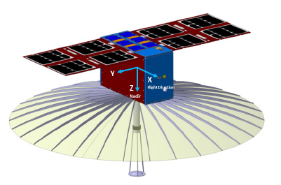
To achieve these goals, MAGAL Constellation is being designed based in six CubeSat, no larger than 24U, flying into a single sun-synchronous Exact Repeat Mission orbit with 97.4º inclination and at a ~500 km altitude, providing full coverage with a 5-day repetition cycle and distance between adjacent tracks of ~88 km at the Equator.
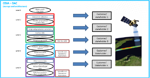
A Data Analysis Center (DAC) is also being developed for data storage and processing, which will also include data from multiple sources (e.g., meteorology) to produce scientific and commercial information. The DAC front-end layer will also allow the display of the data in various graphical interfaces.
Proof of Concept
MAGAL is a proof of concept, can an innovative technological concept such as a constellation of small satellites with radar altimeters, not yet implemented to date, contribute to the future of Satellite Altimetry?
From our studies and analysis, we are convinced YES.
MAGAL Status & Results
MAGAL project was, in first place, a proof of concept of an innovative technological concept.
MAGAL project established its mission requirements from the science objectives and builds its architecture and design on top of them. The required payloads to be included in the MAGAL satellite were primarily searched on market-available COTS, and only whenever we could not identify one fulfilling our needs did, we go for custom development. In this field, MAGAL developed the following custom innovate solutions:
- A small and compact Radar Altimeter, using FMCW technology at 13GHz, with budgets compatible with CubeSat & small satellites.
- Full functional operational prototype developed, manufactured and tested at ground level. Tests in altitude will be performed by the consortium.
- A Data Analysis Centre (DAC) for data storage and processing. This centre shall also include data from multiple sources (e.g., meteorology) to produce scientific and commercial information. The DAC front-end layer will also allow the display of the data in various graphical interfaces.
- DAC developed and implemented using Copernicus, Sentinel, data.
- Simulation tools created to emulate radar altimeter performance and data, as well as MAGAL orbit mechanics. They can be now used to continue develop DAC and implement / validate the processes and algorithms of its services and products.
As main open point of the project MAGAL is its radar altimeter deployable antenna. It was identified that there are no deployable antennas for operating the radar altimeter, at Ku band. Due to budgets and time limitations this payload is not frozen. However, several contacts were performed, and some companies were identified as interested in developing this equipment within fulfilling our requirements.
These custom developments were also identified has having large value in the market as spinoff’s assets of the project.
MAGAL project ends at CDR level for its critical payloads and developments. All its other payloads are between PDR and CDR. All COTS to manufacturer MAGAL are identified and selected, except deployable antenna, which as to be a new development.
It’s time to now market requires a demonstration with a deployment of at least one MAGAL satellite. We are looking for funding to proof the concept. Its consolidation, manufacturing and deployment shall take around 2.5 years.
MAGAL key improvement to radar altimetry is its time resolution of 5 days repetition cycle, with all the other parameters identical. Also, being in “New Space” domain, all costs are much lower.
Concluding, MAGAL project is and end-to-end solution that redefines Radar Altimetry for global oceans monitoring using a new approach based on a constellation of six small satellites and an innovative radar altimeter, that will improve the understanding of ocean circulation variability on local, regional, and global scales by improving the spatiotemporal resolution of sea surface topography measurements, all aligned with the European “New Space” agenda and UN Sustainable Development Goals. MAGAL project is the first proof of concept of such an approach. MAGAL can be the cornerstone for ocean monitoring, bringing it to a more cost-effective Earth Observation due to its reduced production, launch and operational costs, making more frequent and spread ocean data available.
MAGAL Satellite Design & Integration
MAGAL Data Analysis Center Architecture & Demonstrator
Radar Altimeter Prototype

Activities and Results
| Activity 1 | Use Cases and Mission Definition |
| Activity 2 | Constellation Mission Design |
| Activity 3 | Payload Development |
| Activity 4 | Satellite Platform Design |
| Activity 5 | Information and Analysis Center Implementation |
| Activity 6 | Integration and Demonstration of Payload and System Operations |
| Activity 7 | Project Dissemination |
| Activity 8 | Project Management and Coordination |
| Activity 9 | Magal, Ocean Altimetry Constellation Workshop – Atlantic Innovation Week |
| Milestone | Title | Month |
|---|---|---|
| M1.1 | MRR – Mission Requirements Review | 19 |
| M1.2 | PRR – Preliminary Requirements Review | 24 |
| M2.1 | MAR – Mission Adoption Review | 31 |
| M3.1 | P-CR – Payload Concept Review | 28 |
| M3.2 | P-PDR – Payload Preliminary Design Review | 28 |
| M3.3 | P-CDR – Payload Critical Design Review | 30 |
| M3.4 | P-PQR – Payload Preliminary Qualification Review | 31 |
| M4.1 | S-CR – Satellite Concept Review | 31 |
| M4.2 | S-PDR – Satellite Preliminary Design Review | 33 |
| M4.3 | S-CDR – Satellite Critical Design Review | 33 |
| M5.1 | VARSIAC – Validation and Acceptance of the Requirements and Specifications of the Information and Analysis Center | 31 |
| M5.2 | RADIAC – Review of the Architecture and Design of the Information and Analysis Center | 34 |
| M5.3 | RTAIAC – Review, Test and Acceptance of the Information and Analysis Center | 36 |
| M6.1 | SIR – System Integration Review | 33 |
| D6.2 | SPDR – System Pilot Demonstration Review | 36 |
| M8.1 | PKOM – Project Kick-Off Meeting | 1 |
| M8.2 | PCM – Project Closing Meeting | 36 |
| Deliverable | Task | Title | Discloser Level | Status |
|---|---|---|---|---|
| D1.1 | T1.1 | Selected data products and analysis processes for baseline and simulation analyses at local, regional and global climate scales | Confidential | Available |
| D1.2 | T1.1 | Operation and mission requirements for the future constellation | Confidential | Available |
| D1.3 | T1.2 | Payload and platform characteristics and constellation configuration | Confidential | Available |
| D1.4 | T1.3 | Architecture of the business case for the future constellation | Confidential | Available |
| D1.5 | T1.3 | First draft of the business case | Confidential | Available |
| D2.1 | T2.1 | Future MAGAL constellation parameters and characteristics | Confidential | Available |
| D2.2 | T2.2 | Planning, costs and risks of the candidate MAGAL constellation | Confidential | Available |
| D3.1 | T3.1 | Altimeter payload requirements | Confidential | Available |
| D3.2 | T3.1 | Architecture of the altimeter payload | Confidential | Available |
| D3.3 | T3.2 | Antenna specifications | Confidential | Available |
| D3.4 | T3.3 | Complementary payloads for the future MAGAL constellation | Confidential | Available |
| D3.5 | T3.1 | Altimeter payload system design | Confidential | Available |
| D3.6 | T3.1 | Altimeter payload prototype | Confidential | Available |
| D3.7 | T3.2 | Antenna design | Confidential | Available |
| D4.1 | T4.1 | Platform design and architecture | Confidential | Available |
| D4.2 | T4.2 | Structures design and integration plan | Confidential | Available |
| D4.3 | T4.2 | Propulsion system design and integration plan | Confidential | Available |
| D4.4 | T4.3 | Avionics detail design and integration plan | Confidential | Available |
| D5.1 | T5.1 | Models, methodologies and corrections to implement on the information and analysis center | Confidential | Available |
| D5.2 | T5.2 | Requirements and specifications of the information and analysis center | Confidential | Available |
| D5.3 | T5.2 | Design of the different modules of the information and analysis center | Confidential | In Revision |
| D5.4 | T5.3 | Analysis and test of the information and analysis center | Confidential | Available |
| D5.5 | T5.3 | Beta release of the information and analysis center | Confidential | Available |
| D6.1 | T6.1 | Ground tests results | Confidential | Available |
| D6.2 | T6.2 | Report on system assembly and integration | Confidential | Available |
| D6.3 | T6.3 | Validation of the system and integration tests | Confidential | Available |
| D6.4 | T6.4 | Report on altimeter payload demonstration | Confidential | Ongoing |
| D6.5 | T6.5 | Report on information and analysis center demonstration | Confidential | Available |
| D7.1 | T7.1 | Project communication and dissemination plan | Confidential | Available |
| D7.2 | T7.1 | Website and social media | Public | Available |
| D7.3 | T7.1 | Scientific papers and conference presentations (at least 10) | Public | Available |
| D7.4 | T7.1 | First Regional Stakeholder Workshops (West/Southwest Africa) | Public | Available |
| D7.5 | T7.1 | Second Regional Stakeholder Workshop (South America) | Public | Available |
| D7.6 | T7.2 | Final workshop for sustained development platform | Public | Available |
| D8.1a | T8.1 | Project management and financial report (semester 1) | Confidential | Available |
| D8.1b | T8.1 | Project management and financial report (semester 2) | Confidential | Available |
| D8.1c | T8.1 | Project management and financial report (semester 3) | Confidential | Available |
| D8.1d | T8.1 | Project management and financial report (semester 4) | Confidential | Available |
| D8.1e | T8.1 | Project management and financial report (semester 5) | Confidential | Available |
| D8.1f | T8.1 | Project management and financial report (semester 6) | Confidential | Not Issued |
| D8.2 | T8.2 | Project closing event | Public | Available |
Scientific Articles
Conferences and Papers
- IDEIA 2022 – Relevância do Espaço para as Operações Marítimas e Economia Azul, 23rd – 25th February 2022, Escola Naval, Portugal
- “Design de um RADAR Altímetro para CubeSat”, Vitor Coelho, George Xavier, Daniel Albuquerque, Arnaldo Oliveira, João Nuno Matos, Nuno Carvalho, article @ panel #3.2
- ARSI+KEO 2022 – 7th Workshop on RF and Microwave Systems, Instruments & Sub-systems + 5th Ka-band Workshop, 10th – 12th May 2022, ESTEC, Netherlands (Virtual)
- “Simulation of an FMCW RADAR altimeter for a CubeSat”, George Xavier, Vitor Coelho, Daniel Albuquerque, Arnaldo Oliveira, João Nuno Matos, Nuno Carvalho, article @ section 6b
- “Near-Field Impact in the Radar Cross Section for Satellite Remoting Sensing Applications”, Daniel Albuquerque, André Clérigo, Vitor Coelho, George Xavier, Arnaldo Oliveira), João Nuno Matos, Nuno Carvalho, article @ section 3
- “Link budget analysis of an FMCW RADAR altimeter for a CubeSat”, Vitor Coelho, George Xavier, Daniel Albuquerque, Arnaldo Oliveira, João Nuno Matos, Nuno Carvalho, article @ section 3
- 4S Symposium 2022 – Small Satellites Systems and Services, 16th – 20th May 2022, Vilamoura, Portugal
- “MAGAL Constellation – Using a Small Satellite Altimeter Constellation to Monitor Local and Regional Ocean and Inland Water Variations”, André Guerra, André João, Paulo Figueiredo, Miguel Arantes, Miguel Martin, Joaquim Melo, Clara Lázaro, Catarina Cecilio, Inês Castelão, Arlindo Marques, Ana Martins, Catarine Pieper, Manuela Juliano, Rodrigo Lapa, Vitor Coelho, George Xavier, Daniel Albuquerque, Nuno Carvalho, João Matos, Kalvin Brandão, Pedro Lima, Yaroslav Mashtakov, Byron Tapley, Burke Fort, Brandon Jones, Timothy Urban, Zong-Liang Yang, Patrick Heimbach, article @ Science
- 13th CAW – Coastal Altimetry Workshop 2023, 6th – 10th February 2023, Cádiz, Spain
- “Oceans Radar Altimetry with MAGAL Constellation”, Arlindo Marques, Clara Lázaro, Maria Fernandes, Joaquim Melo, André Guerra, André João, Miguel Martin, Miguel Arantes, Paulo Figueiredo, Vitor Coelho, Nuno Carvalho, Catarina Cecílio, Ana Martins, Yaroslav Mashtakov, Edgar Carrolo, Burke Fort, Byron Tapley, article @ session 1
- 74th International Astronautical Congress, 2nd – 6th October 2023, Baku, Azerbaijan
- “MAGAL Constellation Small Satellites for Ocean Radar Altimetry”, Yaroslav Mashtakov, Anna Guerman, Jorge Panagopoulos, Arlindo Marques, Clara Lázaro, Joana Fernandes, Joaquim Melo, article @ section 7-B4
Posters
- Events UT Austin Portugal – October 2021 Porto, Portugal
- “MAGAL Constellation”, Arlindo Marques, Vasco Granadeiro, e-poster
- 2022 Ocean Surface Topography Science Team (OSTST) – OSTST Altimetry 2022, 31st October – 4th November 2022 Venice, Italy
- “MAGAL Constellation”, Arlindo Marques, Clara Lázaro, M. Joana Fernandes, Joaquim Melo, André G. C. Guerra, André João, Miguel Martin, Miguel Arantes, Paulo Figueiredo, Vitor Coelho, Nuno Borges Carvalho, Catarina M. Cecilio, Ana Martins, Yaroslav Mashtakov, Edgar Carrolo, Burke Fort, Byron Tapley, poster
- 16th International Conference on Microplastics and Urban Plastic Pollution (ICMUPP) 2022, 16th – 17th August 2022, London, United Kingdom
- “High-throughput screening of sediments for microplastic pollution: case study using automated mineralogy”, Hamdy, L.B., Rogers, G., Cave, M., Zarketa, O., Emmings, J.F., McGarry, A., Gold, D.P., Martins, A., Pieper, C., Buckley, L. (2022), poster
- 7th International Marine Debris Conference (7IMDC), 18th – 23rd September 2022, Busan, Republic of Korea
- “Marine litter as an ocean climatological variable in the Azores (NE Atlantic): upscale of ongoing and future monitoring strategies”, Pieper, C., Magalhães Loureiro, C., Amaral-Zettler, L., Law, K.L., Reis, J.P., Martins, A. (2022), poster
- Events UT Austin Portugal – October 2022 Matosinhos, Portugal
- “MAGAL Ocean Radar Altimetry, a New Space Approach”, Arlindo Marques, André Guerra, Pedro Lima, Clara Lázaro, Nuno Carvalho, Yaroslav Mashtakov, Catarina Cecilio, Ana Martins, Joaquim Melo, Burke Fort, Byron Tapley, Patryk Heimbach, e-poster
- Events UT Austin Portugal – October 2023 Braga, Portugal
- Arlindo Marques et al, “MAGAL Constellation”, e-poster
Demonstrations
- Space Tech Summer Camp – 1st Edition of the Summer School in Aerospace Technologies 2022, 13th – 15th July 2022, Universidade de Aveiro, Portugal
- Daniel Albuquerque, Vitor Coelho, “RADAR, Earth Observation”
Podcasts
- UT Austin Portugal Podcast “Cross Talks” #8,
- “MAGAL Constellation – Setting the cornerstone of a future ocean and climate change monitoring constellation, based on radar altimeter data combined with gravity and ocean temperature and salinity measurements”, December 2022
Workshop & Presentations
- MAGAL 1st Workshop – MAGAL, Ocean Radar Altimetry, 30th June 2022, UN Ocean Conference Side Event, Lisbon, Portugal
- Space Tech Summer Camp – 1st Edition of the Summer School in Aerospace Technologies 2022, 13th – 15th July 2022, Universidade de Aveiro, Portugal
- “RADAR, Earth Observation”, Daniel Albuquerque, Vitor Coelho
- MAGAL 2nd Workshop – MAGAL: Ocean Altimetry Constellation Regional Stakeholder Involvement, 22nd March 2023, Atlantic Innovation Week, Side Event, Terceira, Azores, Portugal
- MAGAL Final Workshop: MAGAL Altimetry Constellation – Final Workshop, 28th June 2023, Matosinhos, Portugal
Promotors


Partners
Contacts
Arlindo Marques – arlindo.marques@efacec.com

